Garmin GPSMAP 64st
Never available again
View alternatives in the sidebar
View alternatives in the sidebar
According to our hiking navigation system expert
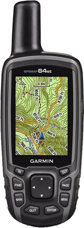
The Garmin GPSMAP 64st is a robust handheld GPS made to show you the way even in the toughest conditions. Thanks to the GPS/GLONASS receiver and the quad helix antenna, your position is displayed faster and more accurately. The 3-axis electronic compass, which also works when you're standing still, and the barometric altimeter will always provide you with all the data you need. You can clearly read the 2.6-inch color display in sunlight, and the device is easy to control with the large buttons that always work. Thanks to the 8GB memory, you can easily load extra maps onto the GPSMAP 64st. This device comes with a basic world map that lets you see where you are anywhere in the world. It also features a recreational topographical map of Europe with road network, contour lines, and a digital elevation model. This device can also display BirdsEye satellite images (1-year subscription included) and link them to your maps.
Wireless connectionsThe Garmin GPSMAP 64st can use ANT+ to connect to other devices, like the Garmin Virb, and sensors, like a cadence sensor, a heart rate sensor, or a temperature sensor. If you have a smartphone with Bluetooth Smart, you can also connect the GPSMAP to your phone using the Garmin Connect Mobile app.
Color screen | ||
|---|---|---|
Type of altimeter | Barometric | |
Built-in camera | ||
Compass | ||
Water-resistant |
5 stars
8
4 stars
22
3 stars
7
2 stars
0
1 star
1
A fast GPS with many possibilities. More than enough memory for loading, for example, both the topographical map of Northern Sweden and the topographical map of the BeNeLux. Compass accuracy is strongly determined by calibration, which can sometimes give different results. Of course it is always advisable to have a normal compass with you when you really go on an adventure. You would expect from such a GPS that a cross bearing is possible, but I have not yet discovered it. In combination with the battery, it seems that the battery is almost empty after only 1-2 hours. However, that indication is incorrect and may not match the characteristics of the battery. Did a test yesterday and the battery lasted 13 hours before giving a red warning signal. Most of the time it only showed 1 bar for the remaining battery capacity. This may be resolved in a future firmware upgrade. Another tip, if you register the device you may receive a discount coupon from Garmin for maps after 1 business day. So don't order it too early.
Ernst-Jan
12 August 2014
Automatically translated from Dutch
Bought this GPS as a replacement for my GPSMAP 60CSx. I use the GPS about 200 days a year and I am not always careful with my stuff, so after more than 6 years the end of the 60CSx was in sight.
The most recent successor to the GPSMAP60CSx is this 64st. In itself a great device, but as you actually read everywhere, the 60CSx was Garmin's best ever...
Also a great replacement. Why the 60CSx is better: battery life, system speed, screen readability (just to name a few..)
I will definitely recommend the GPS, but if you have another 60CSx and want something new, keep your 60CSx (or find a used one..)
Niels
22 August 2014
Automatically translated from Dutch
First of all, again a problem-free order and delivery (on a Sunday and that for free!) by Coolblue and I have already bought a few things online there. Congratulations Coolblue, I will remain a customer! The device itself: works excellently, feels very solid and can be operated well despite the many menus. Admittedly, a little "studying" is necessary, but it all goes smoothly and it is all logically put together, so no problem. It is very handy that a complete user manual can be downloaded from the Garmin website, so download and print it, highly recommended. The supplied map on board (recreation map &/100,000) is good and useful, but considering this as a "topo map" is in my humble opinion something about it, Garmin could do that much better, an included "real" topo map of, for example, BENELUX or one of your choice up to a scale of 1/10,000 would be much better and then we can really speak of a topographic map! Decent OSM maps (open streetmaps) can be downloaded from the web and for free! Garmin maps are very expensive and not always up-to-date! The built-in compass works great, don't forget to calibrate it first, but that works quickly and easily. The battery life is effectively about 10 to 12 hours and not 16 as promised in the specific data. This of course depends on various adjustable parameters etc... In short, so far very good experience with the device, this GPS is more than worth its hard-earned money, so buy it!
Marc Van den Bonne
26 August 2015
Automatically translated from Dutch
Product number | 425527 | |
|---|---|---|
Manufacturer code | 010-01199-21 | |
Brand | Garmin | |
Warranty | 2 years | |
Processing of your defect | Carry-in warranty |
Height | 3,6 cm | |
|---|---|---|
Width | 6,1 cm | |
Depth | 16 cm | |
Weight | 0,26 kg | |
Color | Black | |
Built-in camera |
Screen size | 2,6 inches | |
|---|---|---|
Touchscreen | ||
Color screen |
Global satellite navigation system | GLONASS, GPS | |
|---|---|---|
Quick GPSfix | ||
Trackback feature | ||
Tracklog points | ||
Uploading routes possible | ||
Useful places | ||
Geocache function | ||
Compass | ||
Altimeter | ||
Type of altimeter | Barometric | |
Tide tables | ||
Recommended for activity | Biking, Geocaching, Hiking, Mountaineering | |
Cadence sensor | Yes, sold separately |
Map coverage | Topographic map (Europe) | |
|---|---|---|
Pre-installed maps | ||
Pre-installed countries | Albania, Andorra, Austria, Belarus, Belgium, Bosnia and Herzegovina, Bulgaria, Croatia, Cyprus, Czech Republic, Denmark, Estonia, Finland, France, Germany, Greece, Hungary, Iceland, Ireland, Italy, Kosovo, Latvia, Liechtenstein, Luxembourg, Macedonia, Malta, Moldavia, Monaco, Montenegro, Norway, Poland, Portugal, Romania, Russia, San Marino, Serbia, Slovakia, Slovenia, Spain, Sweden, Switzerland, The Netherlands, Turkey, Ukraine, United Kingdom, Vatican City | |
Maps expandable |
Compatible with smartphone / apps |
|---|
Total storage capacity | 8 GB | |
|---|---|---|
Memory card reader | ||
Memory card | MicroSD |
Power supply type | Rechargeable battery | |
|---|---|---|
Battery technology | Alkaline | |
Maximum battery life | 16 hours |
Water-resistant | ||
|---|---|---|
IP certification | IPX7 | |
Water resistance | Waterproof | |
Dustproof |