Garmin eTrex Touch 25
Never available again
View alternatives in the sidebar
View alternatives in the sidebar
According to our hiking navigation system expert
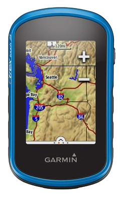
With the Garmin eTrex Touch 25, you'll always know where you are. The device has a topographic map of the whole of Europe installed on it, letting you easily and accurately plan hiking and cycling routes. Your position is very accurately determined, since the device receives both GPS and GLONASS signals. Do you like geocaching? Lucky you. The eTrex Touch 25 has 250,000 caches that need to be found. Good luck!
Color screen | ||
|---|---|---|
Type of altimeter | GPS | |
Built-in camera | ||
Compass | ||
Water-resistant |
5 stars
22
4 stars
31
3 stars
5
2 stars
1
1 star
0
gifted for birthday last week, the birthday boy is full of praise for the device
Pieter
17 October 2015
Automatically translated from Dutch
As a walking GPS it is very good, the default maps are quite accurate, uploading new maps via Garmin express. Trying out the cycling routes this weekend.
Ronald Beckers
13 October 2016
Automatically translated from Dutch
for frequent use. I do geocach with it, hiking and cycling. Each group can be adjusted at will. With the geocach I like the compass when cycling, rather than the speed. Walking routes are very easy to map out on the GPS or via basecamp. I'm happy with it.
ann ceyssens
13 November 2015
Automatically translated from Dutch
Product number | 643294 | |
|---|---|---|
Manufacturer code | 010-01325-01 | |
Brand | Garmin | |
Warranty | 2 years | |
Processing of your defect | Carry-in warranty |
Height | 5,8 cm | |
|---|---|---|
Width | 10,2 cm | |
Depth | 3,3 cm | |
Weight | 159 g | |
Color | Blue | |
Built-in camera |
Screen size | 2,6 inches | |
|---|---|---|
Touchscreen | ||
Color screen |
Global satellite navigation system | GLONASS, GPS | |
|---|---|---|
Trackback feature | ||
Tracklog points | ||
Uploading routes possible | ||
Useful places | ||
Geocache function | ||
Compass | ||
Altimeter | ||
Type of altimeter | GPS | |
Tide tables | ||
Recommended for activity | Biking, Geocaching, Hiking | |
Cadence sensor | No |
Map coverage | Topographic map (Europe) | |
|---|---|---|
Pre-installed maps | ||
Pre-installed countries | Albania, Andorra, Austria, Belarus, Belgium, Bosnia and Herzegovina, Bulgaria, Croatia, Czech Republic, Denmark, Estonia, Finland, France, Germany, Greece, Hungary, Iceland, Ireland, Italy, Kosovo, Latvia, Liechtenstein, Lithuania, Luxembourg, Macedonia, Malta, Moldavia, Monaco, Montenegro, Norway, Poland, Portugal, Romania, Russia, San Marino, Serbia, Slovakia, Slovenia, Spain, Sweden, Switzerland, The Netherlands, Turkey, Ukraine, United Kingdom, Vatican City | |
Maps expandable |
Compatible with smartphone / apps |
|---|
Total storage capacity | 8 GB | |
|---|---|---|
Memory card reader | ||
Memory card | MicroSD |
Power supply type | Battery | |
|---|---|---|
Battery technology | Lithium-ion |
Water-resistant | ||
|---|---|---|
IP certification | IPX7 | |
Water resistance | Splash proof | |
Dustproof |